Step 1 : Sisteron – Saint Geniez

Sisteron Medium
1. Step 1 : Sisteron – Saint Geniez
5h18
14,4km
+846m
-208m
Embed this item to access it offline
Description
This stage winds around the Rocher de la Baume and passes through a national forest that offers a lovely view of Sisteron and its citadel. Along the way, the trail runs below the Vançon National Forest and follows the base of the limestone ridges, a sign that the UNESCO Geopark is already very much in evidence. After a descent along a trail that opens onto the Durance Valley, the path reaches the village of Saint-Geniez, crossing through its farmland.
- Departure : City of Sisteron
- Arrival : Village, Saint Geniez
- Towns crossed : Sisteron, Entrepierres, and Saint-Geniez
Forecast
Altimetric profile
1 point of interest
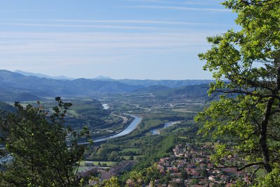
La Durance - CCSB  Lake and river
The Durance River
More than a mere river, the Durance is a force of nature. From its source in Mongenèvre at an altitude of 2300 metres it rolls its way over 302 kilometres until it finally flows into the Rhône. Over time, there has been greater control by man over the river, particularly with the construction of the Serre-Ponçon dam, and it is an essential artery for the Hautes-Alpes.
Source : www.hautes-alpes.net
Report a problem or an error
If you have found an error on this page or if you have noticed any problems during your hike, please report them to us here: