La crête des Barses
Turriers Hard
Hard
La crête des Barses
5h
15,2km
+909m
-909m
Loop
Embed this item to access it offline
Description
- From Turriers, walk up through the village to the town hall square. Take the narrow alley between the houses that branches off to the left behind the fountain and head down to the D 951.
- Cross the bridge to the right.
- From Les Robines, take the small road toward Le Forest and, after a few meters, at the Enchastrayes fountain, follow the path through the woods. Pass in front of a small wayside shrine and immediately turn right.
- At the Chemin de Forest Loin (1,000 m), continue along the road to the left. Pass the Coutarenches trail on your right.
- At Crève Coeur (1,015 m), follow the paved road to its end. Continue along the dirt track that follows it. Pass a descending track on your left.
- The track quickly turns into a trail. Cross the Cougnas ravine (caution: the path is often winding due to severe erosion in the area). Once across, the trail climbs very steeply. It joins a track for a few meters and then winds through marl-rich areas to reach a faint track.
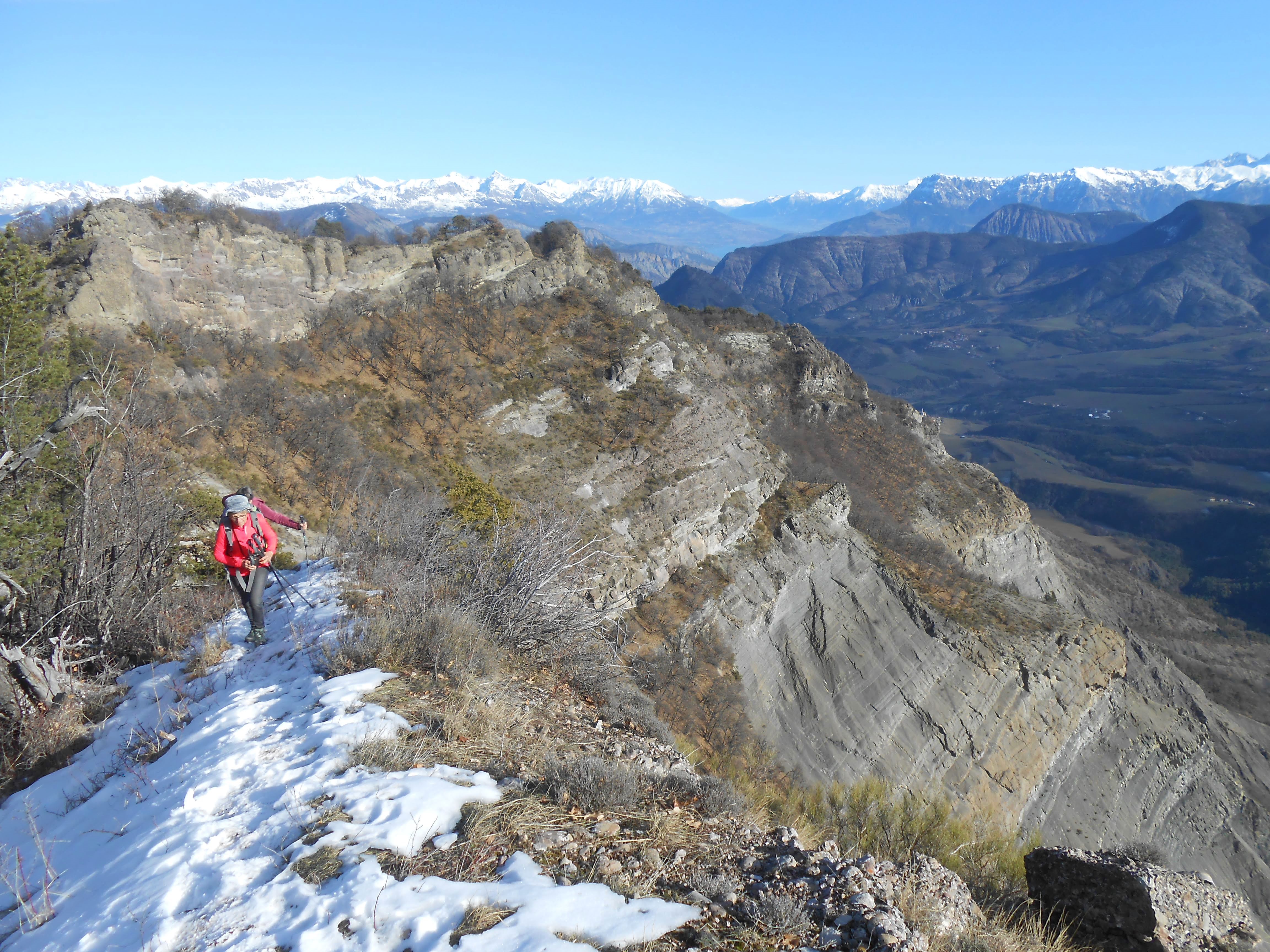
- A beautiful viewpoint on the right offers a view of the Turriers basin.
- At the Col des Rouyères (1,300 m), take the trail to the left behind the sign, leaving the direct ascent to the summit of Les Plauts (difficult) on your right. It quickly turns into a lovely shaded path leading to a ridge.
- On the Crête des Rouyères (1,360 m), follow the trail while staying on the ridge (a mountain bike trail branches off to the left). This trail climbs steeply to the summit of Les Plauts. From there, it becomes very exposed. Shortly after the summit, a trail joins from the right (Col des Rouyères). Several handrails equipped with cables provide safety along the route.
- Once at the Tête de la Plane (1,430 m), the trail descends to the left through a beautiful beech forest. Before heading back down, be sure to check out the orientation table at the summit. A magnificent panorama unfolds from the Dévoluy to the Mercantour.
- At the Plane junction (1,410 m), pass a trail on your left and continue descending through the beech forest.
- At La Dent (1,310 m), a short round trip to the summit of the Dent de Gigors offers a sweeping view of the village of Gigors. Continue along the trail, still descending.
- From the Ubac de Gigors (1,270 m), the trail winds down steep but always shaded slopes in numerous switchbacks. After crossing the Riou Clair stream via a footbridge, head back up quickly to the village. After the fountain, take the path under the house across the street and head to the church on the right.
- At the Gigors Church, take a break to quench your thirst at the five-basin fountain located near the church. Across from the church, between the houses, take a path through the fields.
- At La Chapelle, at the fork in the trails, take the one on the right as you head uphill. At the next intersection, take the left path this time. Just before the bridge, you’ll find the “Talking Rock” on the right. You can listen to a story on your smartphone by scanning the QR code on the rock. After the bridge, the track turns into a trail and crosses the river twice via two fords.
- From Les Clots, take the track that initially runs alongside a field, leaving the footbridge over the Très Pébès ravine on your left. You will soon emerge onto a plateau at the edge of the forest.
- At the Coustarenche road, just before the hamlet, pass a trail on your right. Cross the hamlet, then continue along the D 951 to the right.
- Leave the road and continue left along the trail. It soon crosses a river and gently climbs back to the starting point.
- Departure : Parking lot at the western part of Turriers
- Arrival : Parking lot at the western part of Turriers
- Towns crossed : Turriers, Faucon-du-Caire, Gigors, and Bellaffaire
Forecast
Altimetric profile
Recommandations
- You can listen to a story on your smartphone by scanning the QR code on the Talking-rock
- The ridge trail includes dizzying and challenging sections. For experienced hikers only
- The most exposed sections (which are not necessarily the highest) are secured by a cable
Information desks

Transport
Let’s limit our trips and use public transportation and carpooling: https://zou.maregionsud.fr
Access and parking
From La-Motte-du-Caire (20 km), take the D 951 north to Turriers.
Parking :
Parking lot in Turriers
1 point of interest
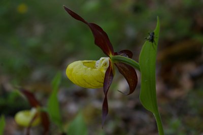
Office de Tourisme La Motte du Caire  Flora
FloraVénus's slipper
A vast family that, according to some authors, comprises more than 25,000 species. Throughout their evolution, orchids have adapted to the presence of insects to ensure pollination, using shape, color, pattern, scent, and other traps. Some, such as the Lady’s Slipper, trap visiting insects that fall into the slipper, forcing them to exit via a path that brings them into contact with the flower’s reproductive parts. Later, once the seeds have formed, they are released by the thousands. These seeds can only germinate thanks to a microscopic fungus they find in the soil, which provides them with an external source of nutrients until the plant can sustain itself. This magnificent flower has three often-colored sepals (see photo) and three petals. Two of the petals are more or less atrophied, while the third, on the contrary, is highly developed and forms the labellum (or slipper). All of them are meant to be picked…only with your eyes!
More information
Report a problem or an error
If you have found an error on this page or if you have noticed any problems during your hike, please report them to us here: